Greenspace to incorporate walking path

The final design now includes a walking path, all while leaving much of the forest in that area untouched, incorporating elements from two different scenarios that had been presented to the community. Courtesy PlanIt Consulting
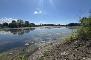
A vision has been set in motion for the greenspace east of the CP tunnel, following over a year of community consultation.
Kahnawa’kehró:non had been presented with two different proposals for the 14-acre stretch of land by the Office Complex along the Old Malone Highway, as part of a project to beautify it and turn it into a more attractive gathering place. Over 150 people weighed in on which design they preferred, said Maris Jacobs, who led the consultation on behalf of PlanIt Consulting.
“People wanted to see features from both, and so we moved forward with creating something that combined both of those things together,” Jacobs said.
The final design now includes a walking path, all while leaving much of the forest in that area untouched, incorporating elements from both of the scenarios that were drafted by a working group of six locals.

Scenario one had included a pedestrian path that would run all the way through the woods, while the second proposed leaving the forest undisturbed. Both plans also included a fire pit that can be used for gatherings.
Those interested in learning more about the plan for the area are being encouraged to stop by the Legion Hall on Saturday, anytime between 10 a.m. and 8 p.m., to learn more about what’s to come. Jacobs will be there to answer whatever questions community members have and take in their feedback.
“The hybrid plan that we’re going to be presenting combines both of those things,” Jacobs said. “There’s a lot of reforestation, but the pedestrian access is reduced significantly from what was proposed in scenario two. So instead of it being a really wide biking and jogging lane, it’s more an accessible path and a trail inside of the greenspace.
“It’s still accessible to people in wheelchairs, and still accessible to walkers and strollers. It’s accessible to motorized scooters, but it’s not open for bicycles or ATVs,” she added. “The path also covers a much smaller surface area than it did in scenario two, so it’s really just about reducing the path size.”




It was Jacques Cartier Champlain Bridges Incorporated (JCCBI) that proposed the plan to redesign the area. They’ll also foot the bill for the $5 million greening project.
The one-KM-long area by the Office Complex was previously used by the federal entity as a worksite for deck replacement work needed for the Mercier Bridge. With it no longer in use, JCCBI decided in 2009 to begin work aimed at revitalizing the area, leading it to hire PlanIt to ensure the vision would be community led.
“JCCBI is offering and funding the project, but they havzzzze agreed to hire local contractors for the work,” Jacobs said, saying outside contractors will only be hired in the instance a local one isn’t available.
Now that a design has been selected, landscape architects can now get to work ironing out exactly how the plan will be executed. Work in the area could begin as early as the summer of 2026, Maris said.
Sign up for email updates from The Eastern Door